Advertzer
Showing posts with label ADVENTURE TOURS. Show all posts

Monday, March 2, 2015

The Nubra Valley (the valley of flowers)

                               The Nubra Valley (the valley of flowers)


The Nubra Valley
Nubra (Tibetan : ལྡུམ་ར; Wylie : ldum ra; English : Nubra) is a tri-armed valley located to the north east of Ladakh valley. Diksit the capital of Nubra is about 150 km north from Leh town, the capital of Ladakh district, India. Nubra Valley Known as Ldumra (the valley of flowers). The Shyok River meets the Nubra or Siachan River to form a large valley that separates the Ladakh and Karakoram Ranges. The Shyok river is a tributary of the Indus river. The average altitude of the valley is about 10,000 ft. i.e. 3048 metres above the sea level. The common way to access this valley is to travel over the Khardung la pass from Leh town. Non-locals require an Inner Line Permit (obtainable in DC office, Leh town) to enter Nubra. Permit is not required anymore for Indian tourists (w.e.f May 1, 2014), though foreign tourists still require the permit.
Until 1994, the lands north of Leh were off-limits to tourists and had been unexplored by outsiders since the nineteenth century. Now, the breathtaking Nubra Valley, unfolding beyond the world’s highest stretch of driveable road as it crosses the Khardung La (5602m), can be visited with a seven-day permit, which gives you enough time to explore the stark terrain and trek out to one or two gompas. The valley’s mountain backbone looks east to the Nubra River and west to the Shyok River, which meet amid silver-grey sand dunes and boulder fields. To the north and east, the mighty Karakoram Range marks the Indian border with China and Pakistan. In the valley it’s relatively mild, though dust storms are common, whipping up sand and light debris in choking clouds above the broad riverbeds.
Before the region passed into the administrative hands of Leh, Nubra’s ancient kings ruled from a palace in Charasa, atop an isolated hillock opposite Sumur, home to the valley’s principal monastery. Further up the Nubra River, the hot springs of Panamik, once welcomed by footsore traders, are blissfully refreshing after a day on a bumpy bus. By the neighbouring Shyok River, Diskit, surveyed by a hillside gompa, lies just 7km from Hundur, known for its peculiar high-altitude double-humped Bactrian camels.
The route north to Nubra, a steep and rough road that forces painful groans from buses and trucks, keeps Leh in sight for three hours before crossing the Khardung La, and ploughing down more gently towards the distant Karakoram Range. Due to its strategic importance as the military road to the battlefields of the Siachen Glacier, the road to Nubra is kept
How to Reach Nubra Valley?
By Road:
The road journey to Nubra valley leads through the world highest motorable road, Khardongla Pass which is at a hight of 18380 ft above sea level and around 50 kms from Leh.
Road Distance:
Srinagar - Leh - 434 Km
Manali - Leh - 473 Km
Srinagar - Kargil - 204 Km
Delhi - Leh - 1047 Kms
Leh - Kargil - 234 Km
Kargil - Padum (Zanskar) - 240 Km
Leh - Deskit (Nubra Valley) - 118 Kms.
By air:
Nearest airport :Leh
Leh is the nearest airport. From Leh, one can hire a taxi or board a bus to reach Nubra Valley. Srinagar is also a good option to reach Diskit. Flights connect Srinagar with Delhi, Mumbai, Bengaluru, Jammu, Leh and Dubai.
By Train
Jammu is the nearest railway station. One can either hire a taxi or board a bus to reach Leh and then Diskit in Nubra valley

Best time to visit Nubra valley:  June To August
Accomodation:
Diskit has guesthouses in mid-budget range. The guesthouses also provide tents for camping. Sumur has deluxe camps with all basic facilities. Hunder also has good hotels.
Places to visit in Nubra valley:
Panamik
Hundur
Diskit
GET DIRECTIONS:
View Larger Map

Monday, June 20, 2011

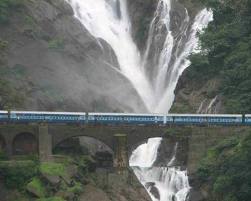
DUDHSAGAR FALLS


Dudhsagar falls is a tiered waterfall located on the Mandovi River in the state of Karnataka, India, on Goa's border with the state of Karnataka. It is 60 km from Panaji. The falls lie high up in the Mandovi River's watershed and so are not particularly spectacular during the dry season. During the monsoon season however, the falls are transformed into one of the most powerful falls in India. Dudhsagar Falls is listed as India's 5th tallest waterfall,and is 227th in the world at 310 m. The water plummets hundreds of feet in large volumes during the monsoon season, forming one of the most spectacular natural phenomena in Goa. It is a major part of the Goa ecosystem.This is a four tiered waterfall with a total height of 310 meters (1017 feet) and an average width of 30 meters (100 feet).

HOW TO REACH DUDHSAGAR FALLS


The waterfall is accessible by train and rough road. It is 10 kilometers from Kulem Railway Station (Indian Railway station code QLM). This waterfalls lies on the Londa-Madgaon railway route. To view this waterfalls from close distance, travel by Delhi-Goa express (12780), Pune-Ernakulam Express(11098), Chennai-VascoDaGama Express or Miraj-Castle Rock passenger train which starts from Miraj rail junction. There is a small rail station about 50 feet near the waterfalls and some trains halt here for 2 mintutes.
GET DIRECTIONS


View Larger Map

Saturday, April 23, 2011

Kaziranga National Park (ASSAM)


Kaziranga National Park is a national park in the Golaghat and Nagaon districts of the state of Assam, India. A World Heritage Site, the park hosts two-thirds of the world's Great One-horned Rhinoceroses. The Kaziranga National Park area consists of 429.93 Sq.Km. with an additional area of 429.40 Sq.Km. The total area of the park within Nagaon district is 175 Sq.Km., out of which 135 Sq.Km. falls under Bagori Forest Range office and 40 Sq.Km. falls within Ghorakati Forest Range office. Located on the edge of the Eastern Himalaya biodiversity hotspot, the park combines high species diversity and visibility.

It is one of the significant natural habitat for in situ conservation of biological biodiversity of universal value. The values and criteria made Kaziranga National Park to get inscribed in the World Heritage Site List 1985. The park is home to large breeding populations of elephants, wild water buffalo, and swamp deer. Kaziranga is recognized as an Important Bird Area by Birdlife International for conservation of avifaunal species. Kaziranga is one of the few wild breeding areas outside Africa for multiple species of large cats, such as Indian Tigers and Leopards.Kaziranga was declared a Tiger Reserve in 2006 and has the highest density of tigers in the world (one per five km²), with a population of 86, as per the 2000 census.
Attractions


Elephant Festival at Kohora: Conceptualized in the year 2003, it is held every January end and entails some enticing activities like adventure sports, procession of decorated elephant, cultural shows, food festival etc.

Sightseeing in Kaziranga: You can enjoy a leisurely walk through the lush rubber and coffee plantations of Karbi Anglong, and the tea gardens of Hathkhuli, Methoni, Difalu, Behora Borchapori. A trip to the nearby Karbi or Mising Villages and acquainting with their living style in the hills can also be very interesting. The Kakochang waterfalls are about 13 km from Kaziranga.

TIMING AND FEE

Park charges are Entry Fee : Rs. 20 (Indians) & Rs. 250 (foreigners), Vehicle Entry : Rs. 200, Still Camera : Rs. 50 (Indians) & Rs. 500 (foreigners), Video Camera : Rs. 500 (Indians) & Rs. 1000 (foreigners), Safari : Rs. 120 (Indians) & Rs. 750 (foreigners).

Park Timings are 7:30 AM to 4 PM

The forest guard (can be hired at Baghori & Agaratoli) traveling with you on a safari doubles up as a guide. There are no fixed charges and you can tip him anywhere between Rs. 50-200.

HOW TO REACH KAZIRANGA NATIOAL PARK

AIR:Nearest airports are at Jorhat (97 km) and Guwahati (217 km). Jorhat is well connected by air to Kolkata which has the International Airport. The airport at Guwahati has regular flights to all major cities of India (including Kolkata).

RAIL: The nearest railway station is Furkating, 75 km from the Kaziranga National Park. Furkating is connected to Delhi through the Brahmaputra Mail and Chennai through the Dibrugarh Exp. Another option would be to travel to Guwahati and board trains for the metros and other important cities in India. For further details, you can log on to the official Indian Railway site (http://indianrail.gov.in).

ROAD: The Kaziranga National Park main gate is at Kohora on the NH-37. It is connected with the major cities like Guwahati, Tezpur, and Upper Assam through a network of private buses. Taxis and buses can be hired from Jorhat and Guwahati.


ACCOMMODATION
The southern fringe of the park has lots of good and affordable accommodation for the visitors. Kohora and Baghori have the major accommodation facilities. You can choose from various types of accommodations like Inspection Bungalows, forest rest houses, hotels and lodges.

GET DIRECTIONS

View Larger Map

Wednesday, April 20, 2011

ELEPHANTA CAVES INDIA (MAHARASHTRA)


ELEPHANTA CAVES INDIA

The Elephanta Caves are a network of sculpted caves located on Elephanta Island, in Mumbai Harbour, 10 kilometres (6.2 mi) to the east of the city of Mumbai in the Indian state of Maharashtra. The island, located on an arm of the Arabian Sea, consists of two groups of caves—the first is a large group of five Hindu caves, the second, a smaller group of two Buddhist caves. The Hindu caves contain rock cut stone sculptures, representing the Shaiva Hindu sect, dedicated to the god Shiva. These caves house rock cut temples dating back to the 5th century CE. The Elephanta island was so named by the Portuguese, after the statue of an elephant near the landing area of the island. The caves are hewn from solid basalt rock. All the caves were also originally painted in the past, but now only traces remain. The main cave (Cave 1, or the Great Cave) was a Hindu place of worship until Portuguese rule began in 1534, after which the caves suffered severe damage. This cave was renovated in the 1970s after years of neglect, and was designated a UNESCO World Heritage Site in 1987 to preserve the artwork.
The island is 1.5 miles (2.4 km) in length with two hills that rise to a height of about 500 feet (150 m). The two hills of the island, the western and the eastern, have five rock-cut caves in the western part and a brick stupa on the eastern hill on its top composed of two caves with few rock-cut cisterns. One of the caves on the eastern hill is unfinished. It is a protected island with a buffer zone according to a Notification issued in 1985, which also includes “a prohibited area” that stretches 1 kilometre (0.62 mi) from the shoreline.
Main cave (SHIVA CAVE)
The main cave, also called the Shiva cave, Cave 1, or the Great Cave, is 27 metres (89 ft) square in plan with a hall called mandapa. At the entrance are four doors, with three open porticoes and an aisle at the back. Pillars, six in each row, divide the hall into a series of smaller chambers.The roof of the hall has concealed beams supported by stone columns joined together by capitals.Usualy entrance of a shiva shrine is in the east-west but here entrance to the main cave aligned with north-south axis. The northern entrance to the cave, which has 1,000 steep steps, is flanked by two panels of Shiva dated to the Gupta period. The left panel depicts Yogishvara (The Lord of Yoga) and the right shows Nataraja (Shiva as the Lord of Dance). Each wall has large carvings of Shiva, each more than 5 metres (16 ft) in height. The main cave blends Chalukyan architectural features such as massive figures of the divinities, guardians, and square pillars with custom capitals with Gupta artistic characteristics, like the depiction of mountains and clouds and female hairstyles.
SHIVA PARVATI ON KAILASH AD RAVAA LITIG KAILASH
The carving on the south wall to the east of the portico depicts Shiva and Parvati seated on their abode Mount Kailash. The carved panel facing this one is a two level depiction of Ravana lifting Kailash. The upper scene is Mount Kailash, where Shiva and Parvati are seated. A legend relates to both these panels.Once, Parvati was annoyed with Shiva. At this moment, Ravana, who was passing by Mount Kailash, found it as an obstruction to his movement. Upset, Ravana shook it vigorously and as a result, Parvati got scared and hugged Shiva. Enraged by Ravana's arrogance, Shiva stamped down on Ravana, who sang praises of Shiva to free him of his misery and turned into an ardent devotee of Shiva. Another version states that Shiva was pleased with Ravana for restoring Parvati’s composure and blessed him.

TRIMURTI GANGADHARA AND ARDHANARISHVARA
The most important sculpture in the caves is the Trimurti, carved in relief at the back of the cave facing the entrance, on the north-south axis. It is also known as Trimurti Sadashiva and Maheshmurti.Described as  a "masterpiece of Gupta-Chalukyan art".
The image, 20 feet (6.1 m) in height, depicts a three-headed Shiva, representing Panchamukha Shiva, The three heads are said to represent three essential aspects of Shiva — creation, protection, and destruction.
The Gangadhara image to the right of the Trimurti, is an ensemble of divinities assembled around the central figures of Shiva and Parvati, the former bearing river Ganges as she descends from the heaven. The carving is 13 feet (4.0 m) wide and 17.083 feet (5.207 m) high.

SHIVA SLAYING ANDHAKA AND WEDDING OF SHIVA
The central figure, which is much ruined below the waist, is measured at 11.5 feet (3.5 m) high, and shows Bhairava, or Virabhadra, a frightful form of Shiva. he niche image carved on the south wall is an ensemble of divinities assembled around the central figures of Shiva and Parvati shown getting married.
YOGISHVARA AND NATARAJA
The panel to the east of the north portico is Shiva in a Yogic position called Yogisvara.The panel carving in the west niche opposite Yogishvara depicts Shiva as Nataraja performing the Tandava (cosmic dance). The niche is 13 feet (4.0 m) wide and 11 feet (3.4 m) in height and set low on the wall.
TIMINGS: OPEN DAILY BETWEEN 9AM TO 5.30 PM (EXCEPT MONDA
ENTRY FEE: Rs.10 FOR INDIAN CITIZENS ABOVE 15 YEARS AND Rs.250 FOR OTHERS ABOVE 15 YEARS
ACCOMMODATION:THERE ARE SO MANY FIVE STAR,THREE STAR AND BUDGET HOTELS IN MUMBAI AVAILABLE FOR ACCOMMODATION.
HOW TO REACH ELEPHANTA CAVES
The Elephanta Caves can be reached by a ferry from the Gateway of India, Mumbai, which has the nearest airport and train station.

View Larger Map

Wednesday, March 16, 2011

RAJAJI NATIONAL PARK


RAJAJI NATIONAL PARK

The park has been created in 1983 by amalgamation of three sanctuaries- Rajaji sanctuary(estd. 1948) Motichur sanctuary (estd. 1964) and Chilla sanctuary(estd. 1977) after the name of renowned statesman and freedom fighter Sri C. Rajgopalachariya - The first and last Governor General of independent India popularly known as "Rajaji". The park is spread over an area of 820.42 sq. km. in three Districts- Dehradun, Haridwar & Pauri Garhwal of Uttaranchal State, India. The majestic Ganges flows through the National Park for a distance of 24km .
The forest ecosystems of the Rajaji National Park are quite varied and diverse.It offers ample opportunities to nature lovers to enjoy the captivating landscape and wildlife.


WILDLIFE ATTRACTION

The park is home to the Tiger, Leopard, Himalayan Bear, Cheetal, hog deer, barking deer, Sambar deer, wild boar, antelopes such as the Nilgai, Goral , Jackal, Hyena, Jungle Cat, Leopard Cat, Civets, Himalayan Yellow-Throated Marten, Sloth Bears, Pythons, King Cobra, Common Krait, Indian Cobra and the Monitor Lizard and above All the Asian Elephant.
Inhabiting the dense green jungles that form the park are an impressive array of creatures - 23 species of mammals - including tigers, leopards, elephants, deer, jungle cat, wild boar and sloth bear - and 315 species of birds are found in Rajaji . The most prominent avian species include pea fowl, woodpeckers, pheasants, kingfishers and barbets, supplemented by a number of migratory species during the winter months. Besides that, the rivers which flow through the park harbour fish such as trout and mahseer.


HOW TO REACH RAJAJI NATIONAL PARK

Rajaji Park, which has several gates, is accessible from Dehradun, Kotdwar and Haridwar: the Ramgarh Gate and Mohand Gate are within 25 km of Dehradun; the Motichur, Ranipur and Chilla Gates are about 9 km from Haridwar; Kunao Gate is 6 km from Rishikesh; and Laldhang gate is 25 km from Kotdwar. Saharanpur, which is conveniently linked by train to other parts of India, is another attractive point to reach the Mohand area of the Park, in nearly an hour by road.

ACCOMODATION
A range of tourist accommodation is available at Rajaji's main campsite. There are Forest rest houses in the surrounding areas of the park. Accommodation is also available in private lodges and resorts outside the Park.
GET DIRECTIONS